

Sales Tax API: How Is the Location of an Address Determined?
Inside the USgeocoder Geocoding Engine
In our previous article, Geocoding and Sales Tax API: Why Address Accuracy Matters, we explained why an accurate address location is essential for determining the correct sales tax jurisdictions and rates.
The next logical question is:
How does a Sales Tax API determine the location of an address in the first place?
When you use Google Maps, you simply enter an address and a marker appears at the correct location.
It feels almost effortless.
In reality, determining the location of an address is one of the most challenging problems in geographic information systems (GIS). Before a Sales Tax API can determine tax jurisdictions, it must first determine where the address actually is.
That process is called geocoding.
More Than Looking Up an Address
At a high level, the process appears simple:
Address → Latitude & Longitude
In reality, producing accurate coordinates requires combining multiple data sources, resolving conflicting address information, standardizing geographic data, and recognizing local addressing patterns throughout the United States.
The final result may be a single point on a map—but arriving at that point is anything but simple.
Inside the USgeocoder Geocoding Engine
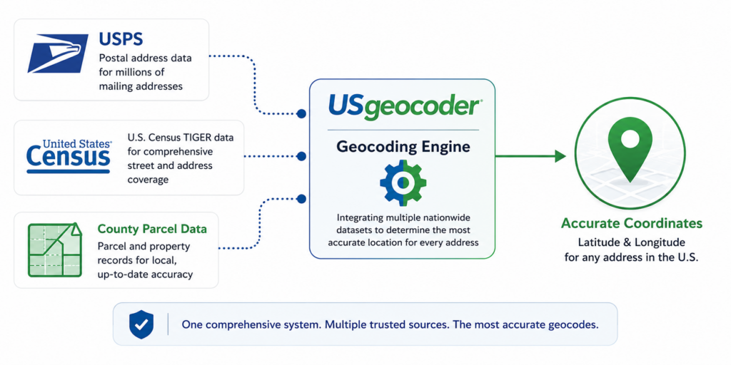
Rather than relying on a single address database, the USgeocoder geocoding engine integrates multiple nationwide datasets into one unified system before determining the location of an address.
This approach improves both geocoding accuracy and address match rates, providing the reliable geographic foundation required by a Sales Tax API.
There Is No Single Address Database
One of the biggest misconceptions about geocoding is that there is one master database containing every address in the United States.
There isn’t.
Instead, accurate geocoding requires combining multiple sources, each contributing different pieces of the puzzle.
| Source | Strength | Limitation |
| USPS | Excellent mailing address coverage | Does not include every physical location |
| U.S. Census TIGER | Broad nationwide coverage | May lag behind new development |
| County Parcel Data | Highest local accuracy | Different standards used by every county |
No single dataset is complete.
Accurate geocoding comes from intelligently combining all of them.
Reconciling Multiple Address Sources
Collecting address data is only the first step.
The real challenge is reconciling multiple address sources to create one consistent representation of every address.
USgeocoder continuously standardizes information from multiple sources while preserving alternate street names, historical names, local naming conventions, and jurisdiction-specific addressing schemes.
The system also applies intelligent address normalization and fuzzy matching techniques to recognize many valid addresses despite abbreviations, spelling differences, or formatting variations.
The result is higher match rates and more reliable geocoding across a wide variety of real-world address formats.
Addresses Change More Often Than You Think
Addresses are surprisingly dynamic.
Roads are renamed.
Cities annex neighboring communities.
Highways often have multiple official names.
Even spelling conventions differ between agencies.
For example:
- Army Street in San Francisco became Cesar Chavez Street before portions later resumed the Army Street name.
- Massachusetts Route 3A is also known as Chief Justice Cushing Highway.
- Martin Luther King Jr Boulevard may appear as MLK Blvd.
- Center Street may also appear as Centre Street or Senter Street.
To people, these variations are easy to recognize.
To a computer, they may appear to be completely different locations.
One of the biggest challenges of geocoding is recognizing that many different address formats actually refer to the same place.
Maps Don’t Always Line Up
Even after address data has been integrated, another challenge remains.
The Earth is round.
Maps are flat.
Every map projection introduces distortion.
Because counties and states often create maps using different projection systems, neighboring datasets don’t always align perfectly.
USgeocoder converts source maps into one consistent nationwide coordinate system before geocoding begins, creating a seamless geographic framework across all 50 states and the District of Columbia.
From Address to Geographic Coordinates
Address
▼
Multiple Address Sources
▼
USPS • Census • Parcels
▼
Normalize & Standardize Data
▼
Resolve Address Variations
▼
Select Best Geographic Location
▼
Latitude & Longitude
Every accurate coordinate begins by integrating and standardizing multiple sources of address information.
Why Every Sales Tax API Depends on This Process
A Sales Tax API doesn’t calculate taxes directly from an address.
It calculates taxes from the geographic location of that address.
Once the location has been accurately determined, the Sales Tax API can identify the jurisdictions that contain that location and return the corresponding tax rates.
Without accurate geocoding, even the best jurisdiction boundary data cannot produce reliable results.
Key Takeaway
Behind every coordinate returned by USgeocoder is a proprietary geocoding engine that integrates multiple nationwide datasets, resolves conflicting address information, applies intelligent matching techniques, and selects the highest-quality geographic location available for each address.
Every address-based answer begins with an accurate location.
 Geocoding and Sales Tax API: Why Address Accuracy Matters