Identify municipality to determine grant prioritization for PA CDFI Network
PA CDFI Network is a statewide collective of mission-driven community development financial institutions (CDFI) that provide affordable loans and technical advisory services to companies unable to access financing through traditional channels. As a 501(c)(3) organization, most of its services are directed to small businesses serving low-income neighborhoods.
PA CDFI recently received the green light to proceed with their HDBA (Historically Disadvantaged Business Assistance) Grant Program.
“PA CDFI needs municipality information to be able to identify which applicants have a business location within a high-crime municipality. Applicants in those areas receive a priority scoring based on if they are in a municipality with a crime rate higher than the state average (18.31 per 1000 people) or a municipality with a crime rate 125% of the state average. Since Police Forces in Pennsylvania are organized by municipality, and not the town/city on mailing addresses, each police force for each municipality reports crime data separately. Therefore, knowing which municipality the applicant’s business is located in was the only way for us to determine if they were in a high-crime area or not.” Explained Dylan Folgesong, Project Manager of PA CDFI Network.
Solution: USgeocoder uses GIS (Geographic Information System) technology to identify the latitude and longitude of the address, then queries its municipality map to produce its municipality.
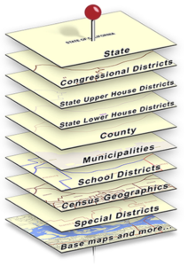
Below is the image that illustrates how municipality information is produced. The pin is the address and each layer of maps the pin can pierce identifies classes of information available for the address. Municipality is a layer of the maps that USgeocoder has. As soon as the location of the address is identified, USgeocoder produces the municipality for the address.
Pennsylvania municipalities are local incorporated government normally referred which may be a city, village, town or township. Although entities with these names are not always municipalities in other states, in Pennsylvania, all these local governments are municipalities with general local government powers differing significantly in the size of their populations.
Each state has different definitions of what their cities, towns, townships and villages are and also differ in what each is allowed to do. Some are general purpose incorporated governments and others are not. A look at a national map of local governments is a very confusing array of terms with very different responsibilities that may or may not be incorporated. For instance towns in Wisconsin are actually un-incorporated townships while townships in New England are actually incorporated as towns. USgeocoder sorts and organizes all this confusion in its map layer of municipalities. (see details on: https://blog.usgeocoder.com/township-municipality/). USgeocoder developed the municipality map according to each state’s definition of municipality to ensure the accuracy of municipality information.
Results: Using USgeocoder’s API, CDFI network could correctly identify which municipality a grant applicant was in. From there, what businesses are in high crime was as easy as seeing the municipal crime rates for each municipality.
“Thanks for the quick turnaround! We are very grateful you were able to do this. It solved a big logistical issue for us!”
By Mr. Dylan Foglesong
Program Manager
PA CDFI Network
(650)417-4229
www.pacdfinetwork.org
